Fight disinformation: Sign up for the free Mother Jones Daily newsletter and follow the news that matters.
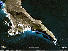 It’s not all bad news from the International Union for Conservation of Nature (IUCN) this week. Today the group, in partnership with Google, launched an interactive marine layer for Google Earth. Users will be able to explore all of the world’s most sensitive ocean areas, as well as upload their own photos and information to the map. Check it out here.
I haven’t gotten to play with this yet, as the layer so far only works with Windows. But my sense is that the combination of solid information and the familiar Google Earth interface will get a lot more people interested in the fate of the ocean. Needless to say, the sooner the better.
Photo used under a Creative Commons license from coda.