New research on Greenland glaciers suggests that sea level rise will be twice as high the Intergovernmental Panel on Climate Change (IPCC) estimate of 18 to 58 cm (0.6 to 1.9 ft) by 2100. The study, published in the Journal of Glaciology (pdf), combines important data long missing from the ice sheet models. Researchers from the University at Buffalo, Ohio State University, the University of Kansas, and NASA, combined field mapping, remote sensing, satellite imaging, and digital enhancement techniques to glean “hidden” data from historic aerial photographs, some 60 years old.
The resulting two-dimensional pictures are of limited value. But the researchers digitized them, removed the boundaries between them, and turned several pictures into a single ‘mosaic’ producing one data set viewable in three-dimensions. “By reprocessing old data contained in these old photographs and records, we have been able to construct a long-term record of the behavior of the [Jakobshavn Isbrae] glacier,” says lead author, Beata Csatho. “This was the first time that the data from the ’40s could be reused in a coherent way.”
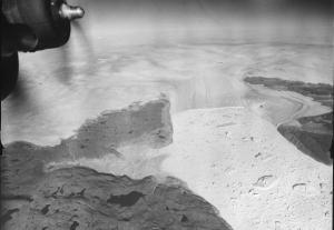
Other glacier views and data here and here.
Julia Whitty is Mother Jones’ environmental correspondent and 2008 winner of the John Burroughs Medal Award. You can read from her new book, The Fragile Edge, and other writings, here.