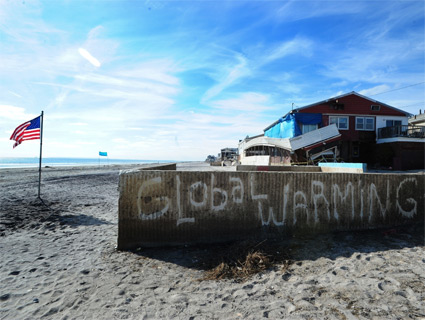
If you’re one of 142 million Americans heading to the outdoors this year, there’s a good chance you’ll run into one of at least 250,000 rivers in the country. Much of the nation’s 3.5 million miles of rivers and streams provide drinking water, electric power, and critical habitat for fish and wildlife throughout. If you were to connect all the rivers in the United States into one long cord, it would wrap around the entire country 175 times. But as a recent assessment by the Environmental Protection Agency points out, we’ve done a pretty bad job of preserving the quality of these waters: In March, the EPA estimated that more than half of the nation’s waterways are in “poor condition for aquatic life.”
Back in the 1960s, after recognizing the toll that decades of damming, developing, and diverting had taken on America’s rivers, Congress passed the Wild and Scenic Rivers Act in 1968 to preserve rivers with “outstanding natural, cultural, and recreational values in a free-flowing condition.” Unfortunately, only a sliver of US rivers—0.25 percent—have earned federal protection since the act passed.
In the interactive map below, we highlight 21 rivers that, based on the conservation group American Rivers’ reports in 2012 and 2013, are under the most duress (or soon will be) from extended droughts, flooding, agriculture, or severe pollution from nearby industrial activity. Find out which rivers are endangered by hovering over them (in orange). Jump down to the list below to read about what’s threatening the rivers. For fun, we also mapped every river and stream recorded by the National Oceanic and Atmospheric Administration. It was too beautiful not to.
Black Warrior River
Areas affected: Alabama
What’s going on? The mining company Drummond has proposed a 1,773-acre coal mine just 800 feet from a major drinking water intake on the river’s Mulberry Fork. Once in operation, the mine could introduce sediment and toxic pollution into the drinking water supply.
What’s at risk? The Black Warrior watershed is home to more than 1 million residents. The river shelters 127 freshwater fish species, 36 mussel species, and 15 turtles species, some of which are federally endangered or threatened.
Catawba River
Areas affected: North Carolina, South Carolina
What’s going on? Power plants in the Catawba watershed have dumped coal ash and scrubber residue into 551 acres of ponds, ultimately contaminating nearby groundwater and drinking water reservoirs with toxic waste.
What’s at risk? More than 1.5 million people in Charlotte, Gastonia, Hickory, and elsewhere depend on the Catawba for drinking water and power generation.
Chattahoochee River
Areas affected: Georgia
What’s going on? Population growth and extreme droughts are making it tougher for Chattahoochee to keep up with demand. Two planned dams and reservoirs could reduce flows to its trout fishery and exacerbate water evaporation from reservoirs during droughts.
What’s at risk? The Chattahoochee provides water to more than 3.5 million people in metropolitan Atlanta. It’s used for irrigation, power, recreation, and boasts a fish and wildlife habitat. Trout Unlimited ranks it among America’s 100 best trout streams.
Coal River
Areas affected: West Virginia
What’s going on? With 20 percent of the Coal’s watershed permitting mining, mountaintop removal mining and valley fills have buried and poisoned about 100 miles of Coal’s headwater streams. A proposal for a 5,000-acre project would involve leveling Coal River Mountain and dumping the soil into nearby streams.
What’s at risk? The Coal, prized for its fishing, kayaking, and canoeing, is on the National Register of Historic Places. It supports one of the world’s most diverse temperate forests, provides habitat for threatened species, and supplies drinking water for nearby communities.
Colorado River
Areas affected: Arizona, California, Colorado, Nevada, New Mexico, Utah, Wyoming
What’s going on? More than 100 dams on the Colorado and its tributaries. Despite benefits like power and agriculture, overallocation and drought have put stress on its reservoirs and water storage. Although current water demand in the river’s basin exceeds what the Colorado can supply, plans for more dams and diversions are underway.
What’s at risk? The Colorado supplies drinking water to approximately 36 million people, supports tourism and recreation valued at $26 billion, and irrigates nearly 4 million acres of land, which is responsible for 15 percent of the nation’s crops.
Crystal River
Areas affected: Colorado
What’s going on? Plans for a new dam, two reservoirs, and a water diversion project threaten to degrade the Crystal and its surrounding habitat. It would flood the nearby Placita wetland, which is a breeding ground for waterfowl, amphibians, neotropical migratory birds.
What’s at risk? The Crystal provides drinking water to at least 7,000 people, supports ranchland irrigators, and is a favorite among fishermen, kayakers, and sightseers. Cutthroat trout, bald eagles, Lewis’s woodpeckers, and rare plant species like the orchid thrive here.
Flint River
Areas affected: Georgia
What’s going on? Urbanization at the river’s headwaters, high demand, intensive agricultural water use, and frequent and prolonged droughts are all straining the Flint’s flow.
What’s at risk? The Flint River provides water for more than 1 million people throughout Georgia, 10,000 farms, and 300 miles of fishing, paddling, and other recreational activities. Severe low flows have already lowered nearby property values and recreational activity.
Grand River
Areas affected: Ohio
What’s going on? Federally protected since 1974, the Grand boasts the best water quality in the Lake Erie Basin. Several natural gas companies have been buying up leases to develop Ohio’s shale gas deposits. Future fracking operations will exacerbate conditions on the river, where fracking wastewater from other states are already ending up.
What’s at risk? The Grand is the most biologically diverse river of its size in the Lake Erie area. It is home to wildlife such as the river otter, showshoe hare, wild turkey, and bald eagle, as well as the steelhead and smallmouth bass.
Green River*
Areas affected: Wyoming, Utah, Colorado
What’s going on? Proposals to build a 500-mile long pipeline, if successful, could divert more than 250,000 acre feet of water from the Green River annually. This could restrict water for agricultural and municipal use in Colorado.
What’s at risk? The Green River is one of the most remote in the US. Several endangered or threatened species, including the Colorado pikeminnow, razorblack sucker, and bonytail and humpback chub thrive in the river.
Hoback River*
Areas affected: Wyoming
What’s going on? The Houston-based energy company Plains Exploration and Production is seeking permission to frack near the headwaters of the Hoback. PXP plans to drill 136 wells from 17 well pads and build or upgrade 30 miles of roads, making the river vulnerable to toxic fracking fluids, sediment buildup in streams from construction, and displacement of wildlife.
What’s at risk? The Hoback is a popular destination for local residents, tourists, and trout fishermen, serving as an important habitat for elk, mule deer, moose, and other big game animals.
Kansas River
Areas affected: Kansas
What’s going on? Draining more than 53,000 square miles of commercial farmland, the Kansas suffers from fertilizer and animal waste pollution. Sand and gravel dredging on the river have widened and deepened the river channel, lowering the water level and cutting off access to water.
What’s at risk? The Kansas (or “Kaw”) provides water for irrigation, public drinking, municipal waste, and for cooling three coal-fired power plants. It is the state’s most popular recreational river, and home to 14 threatened or endangered fish species.
Boundary Waters
Areas affected: Minnesota
What’s going on? The Boundary Waters, which in the past have suffered from extensive mine exploration, are located two miles from the site of a proposed copper-nickel mine. If it gets built, the Boundary Waters will be at risk of toxic metal and chemical pollution from mine waste and will require active water treatment.
What’s at risk? The Boundary Waters Canoe Area Wilderness, covering 1.1 million acres, attracts as many as 250,000 visitors each year. It is home to wolves, lynx, moose, bears, loons, bald eages, and ospreys, and is a popular fishing destination. The US Forest Service estimates that the waters contribute about $100 million to the region’s economy.
Kootenai River
Areas affected: Montana, Idaho, British Columbia
What’s going on? Open-pit coal mining operations are expanding in the Kootenai region, making the waterways and its surrounding habitat vulnerable to selenium pollution, which is considered toxic even at low levels in water.
What’s at risk? The Kootenai is one of the country’s only remaining wild rivers, supporting rare native fish species like white sturgeon and bull trout, and wildlife including grizzly bears and woodland caribou.
Little Plover River
Areas affected: Wisconsin
What’s going on? Irrigation, municipal, and industrial wells are withdrawing groundwater that would otherwise flow into the Little Plover. Between the mid-1970s and 2006, the river lost more than half of its flow. The river, once a favorite for native brook trout fishing, is too shallow to support its fish populations.
What’s at risk? The Little Plover provides water to about 14,000 people, 5,500 acres of irrigated crops, a vegetable processing plant, and a paper mill. The agricultural products grown in the surrounding county are valued up to $145 million.
Missouri River
Areas affected: Iowa, Kansas, Minnesota, Missouri, Montana, Nebraska, North Dakota, South Dakota, Wyoming
What’s going on? More than 75 years of irrigation, dredging, and other techniques to control floods on the Missouri have transformed it into a series of massive reservoirs and a narrow channel along the lower river. Over time, flood damages have worsened and sediment flow through the river has slowed, posing a greater risk to its surrounding communities and wildlife habitats.
What’s at risk? The Missouri River Basin supports about 450 species of birds, fish, and mammals, including the endangered pallid sturgeon, interior least tern, and piping plover. Roughly a quarter of all US agricultural land is in the Missouri watershed, providing more than a third of the country’s wheat, flax, barley, and oats.
Merced River
Areas affected: California
What’s going on? Regulators are currently moving to raise the New Exchequer Dam by 10 feet, which would inundate at least one stretch of the Merced. This could harm native fish and reduce recreational opportunites along the river.
What’s at risk? The lower portion of the Merced, which flows for 135 miles through Yosemite Valley, is home to 26 fish and 136 bird species, including the endangered White-Tailed Kite and Swainson’s Hawk, and the rare limestone salamander.
Niobrara River
Areas affected: Nebraska, South Dakota, Wyoming
What’s going on? Dams and other flood-control structures built along the Missouri River are causing sediment buildup downstream on the Niobrara, at times flooding surrounding croplands and homes. As sediment continues to build up, the Lower Niobrara is gradually losing its seeps, springs, forests, and canyons.
What’s at risk? The Niobrara is home to rare species including the interior least tern and piping plover, as well as bald eagles, river otters, and pallid sturgeon. The area has also been home to the Ponca Sioux and Santee Sioux tribes.
Potomac River
Areas affected: Maryland, Virginia, Pennsylvania, West Virginia, Washington, DC
What’s going on? Though no longer “a national disgrace” as Lyndon B. Johnson once said, the Potomac still suffers from agricultural pollution and runoff from nearby cities. Recent efforts in Congress to roll back provisions under the Clean Water Act, if they succeed, will make the Potomac much more vulnerable.
What’s at risk? The Potomac provides drinking water, habitat for fish, and recreational opportunities to at least 4 million people who trek to the Chesapeake and Ohio Canal National Historic Park each year.
Rough & Ready and Baldface Creeks
Areas affected: Oregon
What’s going on? Several mining companies are planning to explore and develop along the two creeks, which will open up the area to strip mining, road construction, and metal processing. The new mines could pollute the creeks with smelter waste and other toxins.
What’s at risk? The Rough & Ready and Baldface have been considered some of the most pristine rivers in the country, a haven for hikers, wildflower enthusiasts, and salmon and steelhead fishing.
San Saba River
Areas affected: Texas
What’s going on? Wasteful water use and unregulated irrigation are drying up the otherwise scenic and pristine San Saba and the surrounding Hill Country. The result? Some 50 miles of the river runs dry for an average five months each year.
What’s at risk? The San Saba supplies water to nearby cities, livestock, and crop farms, and to Austin’s chain of lakes that flow out to the Gulf of Mexico. It’s home to burr oak and pecan trees, rare mussel varieties, and fish.
South Fork Skykomish River
Areas affected: Washington
What’s going on? A public utility proposal to build a hydropower dam on the Skykomish’s south fork threatens to significantly diminish 2 out of 3 of its dramatic waterfalls, its water quality, and surrounding habitat.
What’s at risk? The Skykomish is one of Washington’s most popular rivers, providing whitewater recreation, angle fishing and hiking opportunities, wildlife habitat, and supports tourism in the nearby towns Skykomish and Index.
*Correction: A previous version of this map showed two versions of the Green River.
**Clarification: American Rivers contacted us to say that while the Hoback River was put on the endangered rivers list at the time of their report in 2012 due to the threat of industrial oil drilling, it’s since been taken off the list as the land in question was purchased and the oil and gas leases are set to be retired.