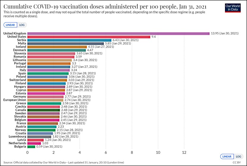

My geophysicist friend tells me that the two big Ridgecrest earthquakes last week happened along fault lines we didn’t even know existed. Here’s a map of all the aftershocks from the two quakes:
The shorter set of aftershocks outlines the area of the 6.4 earthquake. The longer set outlines the 7.1 earthquake. The purple lines show all the previously mapped fault segments in the area. One of those is a potential problem:
My worry is that both of these fault segments were not mapped before, and both lie close to a long fault that ruptured historically. The Garlock Fault lies at the lower right of the figure, trending WSW-ENE, and it produced a 7.5 quake in 1952. For the last few days the folks at the USGS have probably been estimating how many bars of stress have been gained or lost on the Garlock as a result of the quakes that SoCal experienced last week. Although rock stresses are typically measured in kilobars, history tells us that 1-2 bars of additional stress can trigger the next quake. A 7.5 quake would be 0.4 Richter units larger than the Friday quake, roughly 4x larger in energy release. But also along a longer fault that crosses some major highways. I would be concerned for at least the next 12 months.
And that is your earthquake news for the day.